Met Office issues yellow warning for ice in Flintshire overnight
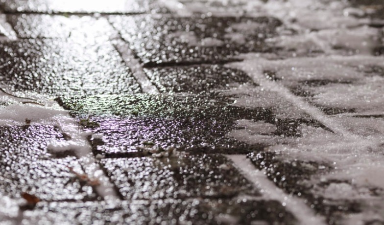
The Met Office has issued a yellow warning for ice which may affect roads and paths in Flintshire this evening and into Tuesday morning.
The warning comes into play at 9pm and is active until 9am on Tuesday.
The warning says: “Ice is likely to develop in places, leading to potentially hazardous conditions.”
The Met Office has said: “Showers this evening, wintry over high ground, will gradually die out overnight.”
“Wet surfaces are expected to fall below freezing quite quickly under clear skies.”
“Ice is quite likely where surfaces remain untreated, or where showers wash off grit.”
What to expect
- Probably some icy patches on some untreated roads, pavements and cycle paths making accidents and injuries more likely.
Storm Barra
The Met Office has said there is potential for a spell of very windy weather in Flintshire on Tuesday.
Names Storm Barra by the Irish Meteorological Service, is forecast to bring strong winds to much of the UK.
Forecasters say we could see gusts reach between 45 to 50 mph widely, with 60 to 70 mph possible in coastal locations.
A yellow weather warning for storm force winds will come into force at 9am on Tuesday and will remain in place until midnight.
As a result of the windy weather, forecasters say there could be:
- Some delays to road, rail, air and ferry transport are likely
- Probably some bus and train services affected, with some journeys taking longer
- Delays for high-sided vehicles on exposed routes and bridges likely
- Some short term loss of power and other services is possible
- It’s likely that some coastal routes, sea fronts and coastal communities will be affected by spray and/or large waves
Frank Saunders is a Chief Meteorologist at the Met Office. He said: “Strong winds arriving across the west through Tuesday morning, will spread inland and reach eastern areas through the afternoon and early evening. Gusts of 45-50 mph are expected widely, with 60-70 mph in exposed coastal locations. The strongest winds will ease across inland areas into the overnight period.”
Deputy Chief Meteorologist, Brent Walker said: “A band of rain will turn to snow across northern England and Scotland through Tuesday. Two to five cm of snow is expected to accumulate quite widely across the warning area, but locally this could reach ten cm, particularly in parts of the Southern Uplands and Highlands.”
He added: “Strong south-easterly winds will also lead to snow drifting in places, particularly over the highest routes, adding to poor visibilities.”
Storm Barra – the second named storm of the season – is a name selected as part of the Name Our Storms collaboration with Irish forecasters Met Éireann and Dutch forecasters KNMI.