Work progressing well on new footway and cycleway to improve travel between Aston and Hawarden

Work is progressing well on a major scheme to improve pedestrian and cyclist safety along Upper and Lower Aston Hall Lane, with a new shared footway and cycleway beginning to take shape.
The Flintshire Council-led project is designed to enhance active travel links between Aston and Hawarden, with a focus on creating safer, more accessible routes for everyday journeys and school commutes, particularly to Hawarden High School.
Construction is visibly underway, with a clear route now emerging alongside the existing road.
The work involves widening footways to accommodate shared use by pedestrians and cyclists, trimming back overgrown vegetation to improve visibility, and modifying safety barriers where necessary to allow for the expanded path.
To improve road safety and reduce traffic speeds, junctions along the route are being redesigned with priority changes, tighter turning radii, and the installation of raised tables.
New dropped kerbs are also being added to make crossings more accessible for pushchairs, wheelchairs and mobility scooters.
Traffic calming is a central theme throughout the scheme, with the introduction of sinusoidal humps, central road markings to visually narrow the carriageway, and regular cycle symbols to remind drivers to expect cyclists on the route.
Sinusoidal humps are a type of road hump designed to reduce vehicle speeds in a smoother, less jarring way than traditional speed bumps or cushions.
The project also includes the construction of a new off-road shared path in key areas, and under the railway bridge near Aston Hall Farm, a new ‘priority working’ system will favour southbound traffic to allow protected space for cyclists and pedestrians.
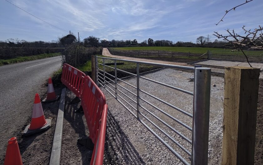
Although some areas such as the narrow bridge section will retain their current width due to structural constraints, they will still be designated as part of the shared route.
Across the scheme, shared-use paths typically measure between 3.0 and 3.5 metres wide.
Tactile paving is being installed at key crossing points to support visually impaired pedestrians, and existing public rights of way are being preserved and integrated into the improvements.
A spokesperson for Flintshire County Council said: “We appreciate the continued cooperation and support of the local community during these essential works, which will deliver long-term benefits for all.”
Spotted something? Got a story? Send a Facebook Message | A direct message on Twitter | Email: [email protected]
Latest News