Posted: Mon 10th Aug 2020

Potential for strong to severe thunderstorms in Flintshire today

News and Info from Deeside, Flintshire, North Wales
This article is old - Published: Monday, Aug 10th, 2020

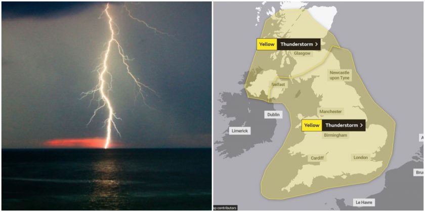
The hot weather is creating ideal conditions for thunderstorms which are expected bring to heavy rain and increasing risks from flash flooding, lightning and hail to parts of the region later today.

Yellow thunderstorm warnings are in place in Flintshire and across the country between now and Thursday.

Today thunderstorm warnings cover much of the UK away from northern Scotland warning of the risk of heavy showers, frequent lightning and gusty winds with 30 to 40mm of rain possible in an hour.

However, Chief Meteorologist Steve Ramsdale says; “a second yellow thunderstorm warning is also in place for parts of North West England, North Wales and West Midlands where the worst of the storms are likely to occur. Here exceptional rainfall totals could be seen of 60mm in an hour with a very small chance of 150mm of rainfall in 3 or 4 hours”.

The Met Office said, “severe thunderstorms may bring disruption to travel and power supplies as well as some damage to buildings.”

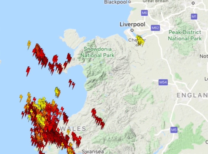
Map shows Lighting strikes being recorded in North Wales and Cheshire at 12:30pm

These may contain large and damaging hail, torrential rain, frequent lightning and possibly very strong and gusty winds.

Whilst many areas will see some heavy rain, hail and thunder at times where the worst of the storms occur some exceptional rainfall totals are possible.

60 mm of rain is possible in an hour with a very small chance of 150 mm in 3 or 4 hours.”

According to Netweather.TV the storms are “capable of producing large hail of 3-4cm.

What what the Met Office has said to expect:

  • There is a small chance that fast flowing or deep floodwater could suddenly occur, bringing a danger to life and rapid flooding of homes and businesses
  • There is a slight chance power and other essential services, such as gas, water or mobile phone service will be lost
  • There is a slight chance of damage to buildings/structures from lightning strikes, large hail, or strong winds
  • There is small chance that spray, sudden flooding, standing water and/or hail will result in rapidly changing, dangerous driving conditions
  • If flooding occurs road closures with long delays and cancellations to bus and rail services are possible
  • There is a small chance communities may be completely cut off
  • ad

    Spotted something? Got a story? Send a Facebook Message | A direct message on Twitter | Email: [email protected] Latest News

  • Suspects caught after Connah’s Quay van crash
  • Police issue fresh appeal for witnesses following fatal collision on A41 in Chester
  • North Wales firefighters warn after BBQ and garden fires spark callouts over weekend

  • More...

    Suspects caught after Connah’s Quay van crash

    News

    Police issue fresh appeal for witnesses following fatal collision on A41 in Chester

    News

    North Wales firefighters warn after BBQ and garden fires spark callouts over weekend

    News

    North Flintshire Police respond to 166 incidents over busy weekend

    News

    Fears bus reform plans will exclude views of elderly people

    News

    Deeside Round Table: Local businesses urged to back Hawarden car show with prize donations

    News

    Prolific Chester offender jailed over £5k tool theft

    News

    Flintshire planners urged to reject padel court plan near Broughton

    News

    Plan to turn Buckley police station into five apartments backed for approval

    News