Met Office issues snow and ice warning for Flintshire as cold front approaches
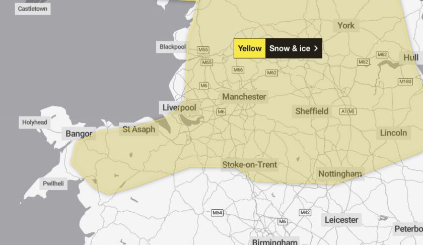
Flintshire, along with Cheshire, Denbighshire, and Wrexham, is among the areas covered by a Met Office yellow warning for snow and ice. Conditions could cause disruptions from 7.00 pm on Monday, 18 November, until 10.00 am on Tuesday, 19 November.
The warning comes as colder Arctic air moves south, bringing a mix of rain, sleet, and snow to North Wales and parts of northern England.
While snow is most likely to settle on higher ground—5–10 cm above 200 metres and 15–20 cm above 300 metres—there is a chance of significant snowfall at lower levels, which could cause travel issues during Tuesday’s rush hour.
Chief Meteorologist Andy Page said: “We have issued yellow warnings for snow and ice as cold weather moves in from the north.
“This brings snow showers and some ice to parts of Scotland on Sunday night, and then the potential for a spell of snow to lead to disruption to some transport routes across a central swathe of the UK on Tuesday morning.
“Gusty winds in the east also remain a potential hazard.
“Updates to the warnings for wintry hazards are likely, so it is important to stay up to date with the latest forecast.”
Longer-Term Impacts
The snowfall coincides with a Cold Weather Alert issued by the UK Health Security Agency (UKHSA) for the Midlands and North of England, with health services preparing for increased risks to vulnerable populations.
Despite North Wales being included in the weather warning, the UKHSA alerts have never applied to Wales, oddly.
As the snow clears on Tuesday morning, icy conditions are likely to form on untreated surfaces, further complicating travel and daily routines.
Why Is It So Difficult to Forecast Snow?
Snow forecasts can generate sensational headlines, but predicting snow in the UK is complex, the Met Office says.
Factors such as air origin, precipitation intensity, and weather fronts between warm and cold air play key roles in snow formation.
While it’s tempting to rely on long-range predictions, snow forecasts are most reliable a few days in advance.
Met Office meteorologists use multiple weather models to assess probabilities but caution against certainty in headlines predicting snow weeks ahead.
Currently, a colder spell is likely, increasing the chances of frost, ice, and snow on high ground.
However, there is still uncertainty about snow at lower levels.
What the Alert Tells Us to Expect
- Power and Communication Disruptions: A small chance of power cuts and interruptions to mobile phone coverage.
- Impassable Pathways: Untreated pavements and cycle paths may become impassable.
- Rural Isolation: There is a slight chance that some rural communities could be cut off.
- Transport Delays: Bus and train services may be delayed or cancelled, with road closures and longer journey times likely.
- Injuries on Icy Surfaces: There is a small chance of slips and falls on icy pavements and roads.
- Travel Challenges: There is a small chance of vehicles and passengers becoming stranded, with rail and air travel also facing delays or cancellations.