Flood alert no longer in place for River Alyn in Mold

Update: The flood alert no longer in place for River Alyn in Mold.
Earlier report: A flood alert has been issued for the River Alyn in Mold as Storm Franklin bring gale-force winds and heavy rain to Flintshire.
A yellow weather alert is active until 1pm as the third named storm in a week sweeps across the UK.
The flood alert issued by Natural Resources Wales states:
The areas around Leadmill, Ponterwyl, Glanyrafon, Pentre and Broncoed are at risk.
“Some localised flooding problems may result from surface water.”
“River levels are above normal. We will continue to monitor the situation.”
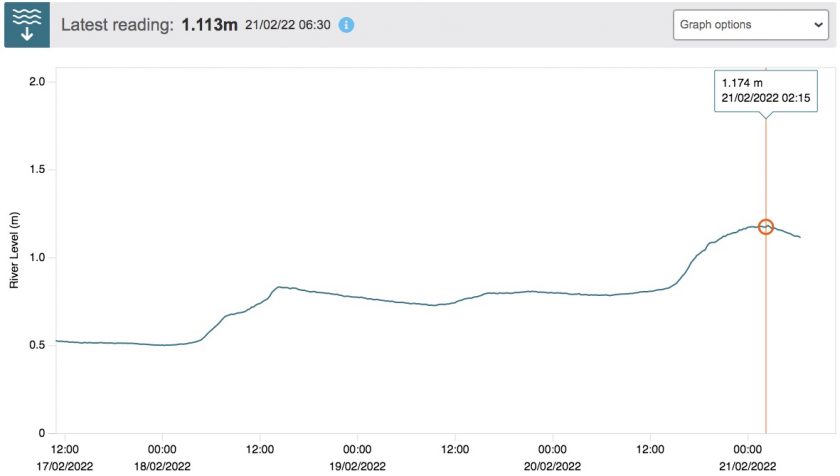
Average levels for the River Alyn at Leadmills is around just over 0.5m, at a peak [2.25am] the river levels reached 1.174m.
The latest reading shows the river level has subsided slightly.

A flood alert is also in place for the areas along the North Wales coast from the Dee estuary to the east coast of Anglesey
A flood alert is the lowest level of warning Natural Resources Wales issues it means flooding is possible and you should be prepared
- Forecasts indicate that flooding from rivers may be possible
- Forecast of intense rainfall for rivers that respond very rapidly
- Forecasts of high tides, surges or strong winds
- Be prepared to act on your flood plan
- Prepare an emergency flood kit of essential items
- Avoid walking, cycling or driving through flood water
- A Flood Alert could be upgraded to a warning so check for updates regularly
The latest storm follows on from a week in which Storm Dudley and Storm Eunice also impacted the UK, although wind gusts from Storm Franklin are expected to be lower than Eunice which triggered two Red Weather Warnings.
The centre of Storm Franklin will track eastwards over the north of Scotland from early Monday morning, with the highest winds expected on the southern flank of the system.
The centre of Storm Franklin will clear into the North Sea on Monday morning, although high winds will continue to be felt for most through Monday, as is reflected in the Yellow Weather Warning.
Met Office Chief Meteorologist Andy Page said: “Following the significant impacts of Storm Eunice on Friday, Storm Franklin will bring further high winds for many late on Sunday and into Monday, although not on the same scale as Eunice.
“Coastal areas of Northern Ireland, especially on that north coast, will get the strongest wind gusts, which could be around 80mph in a few places. Amber and Yellow Wind Warnings have been issued, and people should remain cautious ahead of the system that will bring 50-60mph wind gusts for much of the UK from late on Sunday and through Monday.”
Spotted something? Got a story? Send a Facebook Message | A direct message on Twitter | Email: [email protected]What is the difference between a flood alert and a flood warning?
Latest News


