Souvenir brochure charts opening of Queensferry Bypass and Bridge in 1962
Over sixty years on from the opening of the Queensferry Bypass and Bridge, a fascinating document marking this historic occasion has been shared with Deeside.com.
The bypass and bridges were opened on Friday, March 2, 1962, and the occasion was marked with a commemorative brochure, a copy of which has been shared with us by Paul Davies from Deeside.
Many discussions have taken place over the years regarding traffic relieving road improvements on the main arterial route into North Wales from England and mooted A494/A55 red route.
But there looks to be no prospect of anything happening any time soon.
Sixty years on from the official opening of the bypass and bridge, we take a look back at this moment in history.
Queensferry’s road and railway bridges and bypass were opened in an era when shift dresses were the height of fashion and Elvis Presley’s Can’t Help Falling In Love was topping the charts, closely followed by Cliff Richard with Young Ones.
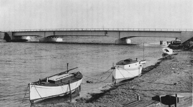
A section of the road looking north towards the River Bridge nearing completion
Harold Macmillan was the Conservative Prime Minister at this time and it would be around 37 years before the National Assembly for Wales was created, the forerunner of the Senedd Cymru we know today.
According to the Met Office, Wales had the coldest month on record for the UK at 1.9 degrees celsius in March 1962, with significant snowfall.
Those rolling up their sleeves to build the bridge and the road had to do so while braving the elements, while those dressing up in their finery to attend the opening ceremony must have been well wrapped up against the cold.
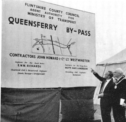
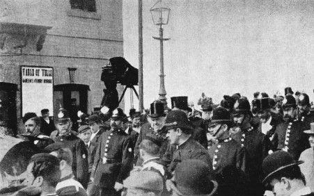
The Minister of Transport inaugurating the scheme with him is Alderman A. G. Moyle, J.P. (the then Chairman of the County Council)
An opening ceremony was carried out by Minister of Transport, the Right Honorable Ernest Marples MP. Ernest Marples is pictured in the souvenir brochure looking very smart in a dapper suit, shirt and tie, complete with pocket handkerchief, and is poised ready to sign an undoubtedly very important document.
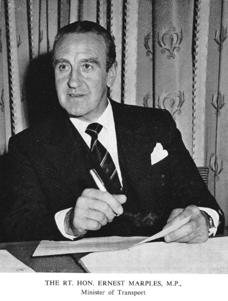
The Right Hon Ernest Marples MP, Minister of Transport
The brochure also includes a photo of the proud members and officers sitting on the Queensferry Bypass and Bridge Committee, including a dapper Flintshire County Council chairman, councillor Dennis Griffiths, J.P., pictured second from left in the front row and wearing a fetching bow tie.
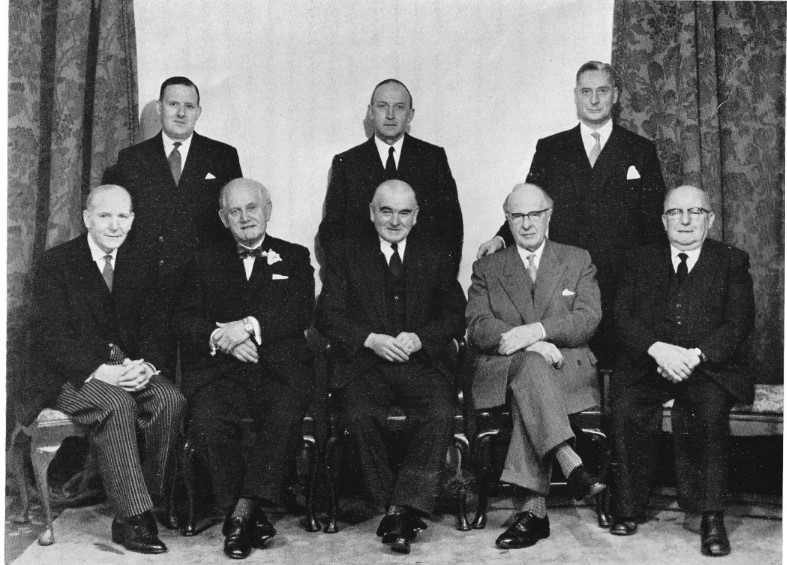
Members and officers sitting on the Queensferry Bypass and Bridge Committee in 1962. Back row — Mr. T. M. Haydn Rees (Deputy Clerk) Mr. E. W. W. Richards (County Surveyor and Bridgemaster) Mr. Sidney Elmitt (County Treasurer). Front row — Mr. W. Hugh Jones (Clerk of the County Council) Councillor Dennis Griffiths, J.P. (Chairman of the County Council) Alderman A. G. Moyle, J.P. (Chairman of the Committee) Alderman Sir Geoffrey Summers, BT., C.B.E., D.L., J.P. Alderman P. T. Trehearn, J.P., (Vice-Chairman of the County Council) Alderman H. R. Thomas, C.B.E., LL.D., J.P. is also a member.
The main contractors for the work were Messrs. John Howard & Company Ltd, of Westminster, London, and the cost of the contract was £695,337. 9s. 6d. Of this figure, £241,857. 4s. 6d. was said to have related to bridgeworks and £453.480. 5s. Od. to the roadworks.
The poetic introduction to the commemorative brochure reads: “The River Dee is of considerable historic interest from source to mouth, especially that stretch of the river from Chester to the sea.
“Its moving sands, with their influence on the navigation of the river and the means of transit across it, have provided a theme for the novelist and the poet.
“The maintenance of its navigable channel has, for centuries past, been a matter of interest to travellers, traders and engineers, and has occupied the attention of Parliament on many occasions.
“It is, therefore, not unfitting on the occasion of the opening of the By-Pass and the third bridge, providing improved facilities for transport, that a brief reference should be made to the evolution of the means of transit across this interesting waterway.”
View from bridge over road at R.A.F. Station, Sealand, looking towards Birkenhead in August, 1950
The brochure charts the history of bridge and road building in this area, as follows.
“One of the earliest records of a common crossing of the river below Chester is that which states that passengers went by an undefined road over the estuarine flats between Shotwick Castle on the North to Flint Castle on the South.
“This was the usual route during the seventeenth century and the early part of the eighteenth century. The main stream of the river was forded below Connah’s Quay, and the crossing was said to be so precarious that travellers were fortunate if they reached the other side with no worse trouble than the inevitable wetting.”
Calls were made for ferry boats to be introduced to make crossing the river easier and safer, and this was made possible with the passing of the River Dee Act in 1732. Two ferries were then established in 1740, known as Higher and Lower Ferry. The former was in what we now know as Saltney and the latter as Queensferry.
Free ferries were introduced following an act passed in 1743 and they continued to run for 150 years. A photo included in the brochure shows “the old Queensferry Boat icebound” during a bitter winter in January, 1895.
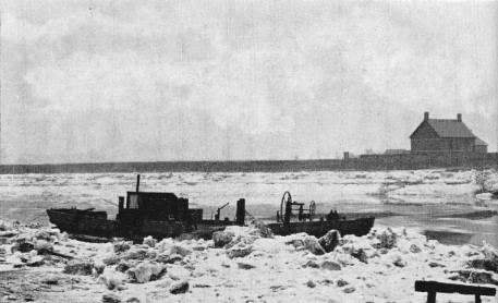
The old Queensferry Boat icebound, January, 1895
The brochure also includes a fascinating photo of when the former Prime Minister, William Gladstone opened the retracting Victoria Jubilee Bridge in 1897. The building of the bridge was authorised by the Queensferry Bridge Act 1894.
The Rt. Hon. W. E. Gladstone, M.P. at the opening of the Victoria Jubilee Bridge
The brochure then goes on to chart the building of the “new” bridge and bypass, ahead of the official opening.
“In Flintshire, the section of Trunk Road A.494 which passes through Queensferry carries the traffic which flows along both the main traffic route through the heavily industrialised coastal belt of the County (A.548) and also the main Trunk Road (4.55) which passes axially through the County, parallel to the coast line, and serves the holiday resorts in the North of Flintshire and the North Wales coast line generally.
“It carries, therefore, a large volume of heavy, short range, industrial traffic serving large manufacturing and processing concerns which are of national and not merely of local importance, and, in addition, during the holiday season and at week-ends, large volumes of holiday traffic journeying to the holiday resorts of North Wales, in Flintshire and beyond, which are the natural recreational outlets of the large conurbations of Lancashire and the Midlands.
“This traffic is not only large in volume but could, by reason of the comparatively short distances to the large Urban conurbations which have been mentioned, accumulate and choke the road in a very short space of time under the conditions which existed before the construction of the By-Pass.
“The result was delay and unnecessary expense to commercial users of the road and frustration and annoyance to the other traffic which was simultaneously using it. Since before the 1939-45 War, it had been obvious to the County Council that there was a need for a By-Pass and new Bridge, and representations were constantly made to the Ministry of Transport and deputations attended upon the Minister.”
An extract from a local newspaper printed in “Whitsun 1951” is shared here. This states that unprecedented traffic for Flintshire had been experienced on Whit Monday night as people headed home from the North Wales coast. A “continuous line” of traffic is reported from Rhyl to Queensferry and this hadn’t cleared Flint until around 11.30pm and Shotton until nearly midnight .
Details of the development were set out in the brochure as follows.
“The Project is shown on the Key Plan and falls, descriptively, into the following parts:—
“The Road Works
“These consisted of the construction of a new road to form a By-pass to the East of the town of Queensferry on the Dolgelly—South of Birkenhead Trunk Road (A.494).
“The new road is approximately 1.7 miles in length and of an overall formation width of 80ft. comprising dual carriageways 24ft. wide, a central reservation 10ft. wide, two verges 8ft. wide and a footpath, on the Western side, 6ft. wide.
“The work also included the re-grading, re-shaping and re-alignment of the existing Trunk Road at the Northern and Southern junctions with the By-Pass, the diversion of Gladstone Way (A.550) for approximately 400 yards of its length, the diversion of Sandycroft Road (B.5129) for approximately 300 yards of its length, the diversion of Sealand Road (A.548) for approximately 120 yards of its length, and the provision of a new access road to the Midland Tar Distillers Limited works approximately 90 yards in length.”
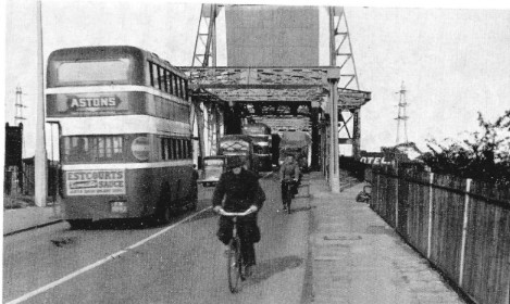
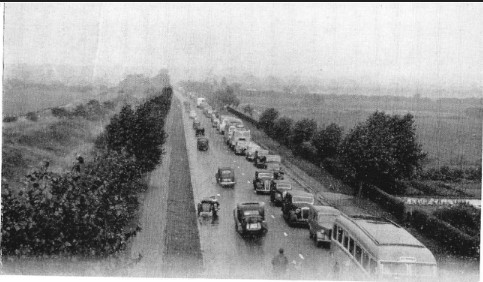
Traffic congestion on Second Queensferry Bridge, September, 1950
The brochure then takes on something of a philosophical tone, featuring a prediction of possible future solutions to the traffic problems, with the bold inclusion of likely costs being a staggering £15million.
“What of the Future? The County Council is in no doubt that, eventually, the final answer to the road traffic problems in this area, and to the development of North Wales generally, is the construction of an embankment and bridge across the Estuary of the River Dee somewhere between Gayton on the Wirral Peninsula and Greenfield in Flintshire.
“The investigations made so far jointly on behalf of the County Council and the River Board suggest that though there are many complicated legal, engineering, land and administrative problems to be overcome, the scheme is feasible and has far reaching possibilities.
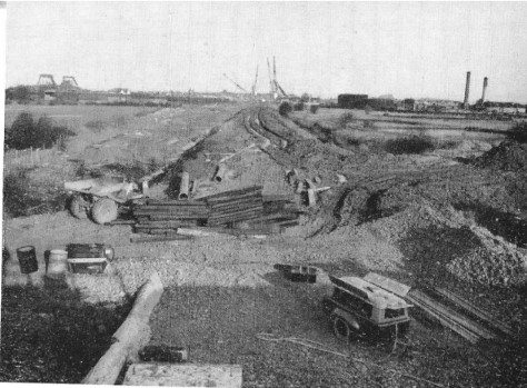
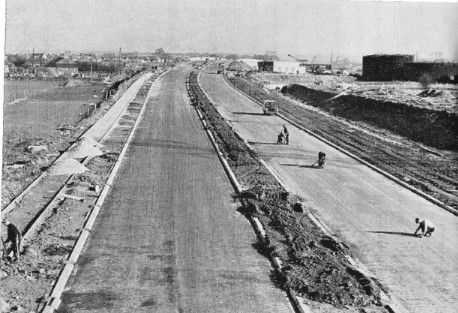
A section of the road during construction looking North towards the River Bridge
“Consultants have carried out investigations on behalf of the Board since 1936, and in recent years on behalf of the Council and the Board, and from tidal flow experiments on models of the Estuary the conclusion reached has been that the Greenfield-Gayton route was the best.
“A conference of Local Authorities was held at Mold, and subsequent discussions have taken place between Officers of the Cheshire and Flintshire County Councils, as a result of which the respective County Surveyors have taken preliminary origin and destination surveys of traffic likely to use a bridge across the Estuary.
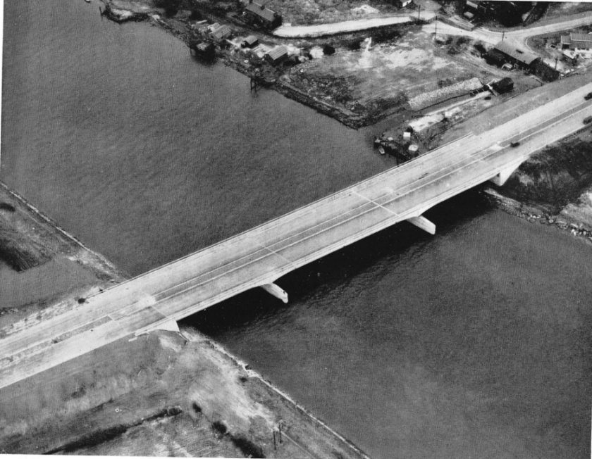
The new river bridge
“Put briefly, it shows that the equivalent of 15,000 cars per day would use this bridge in the Summer and the equivalent of 11,500 cars per day in the Winter. On this evidence there is a clear demand for the facilities.
“The cost? There are at this stage so many imponderables that no really accurate figure is possible, but it would probably be of the order of £15,000,000.
“Large though this cost may appear to be, the County Council and other industrial and Trade Union organisations in North Wales are firmly of the opinion that the benefits of the construction of such a crossing over the lower reaches of the River Dee would amply repay the capital investment involved and would be reflected throughout the whole of North Wales and North West England.”
The brochure concludes with a thank you to the Ministry of Transport staff for their “outstanding” support.
Today..
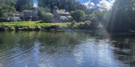
Today the A494 River Dee crossing carries over 60,000 vehicles a day many more than it was designed for.
In 2019, the Welsh Government said that due to the age of the bridge there has been deterioration to some structural features and it would be difficult to maintain long-term.
Work is in the pipeline to upgrade the crossing which will include a new bridge and the ‘partial’ re-use of the existing crossing.
It’s not clear when the project will begin, last year the Welsh Government halted all new road building project including the so called A494 Red Route.
[The upgrade is a key part of the Welsh Government’s plans to improve transport infrastructure and resilience in North Wales.]
Three lanes into two just doesn’t go…
A major improvement scheme which aimed to address congestion along the A494 corridor was shelved following a Public Inquiry in 2007.
The first phase of the ‘superhighway’ project saw the A494 from Deeside Industrial Park to Drome Corner upgraded in 2004.
Alfred McAlpine was awarded a £49m contract to further expand a 2.5-mile stretch of road from the River Dee in Queensferry to Ewloe to seven lanes plus hard shoulders.
But the Welsh Government ditched plans following a fierce battle with local residents concerned about the increase of traffic, pollution and noise.
At the time Minister for Economy and Transport, Ieuan Wyn Jones agreed with a Planning Inspector’s recommendation that the scheme should not proceed any further due to the impact on the local community.
A total of 2,300 objections were submitted and a public inquiry led by inspector Neil Taylor was held in September and October 2007.
The Deputy First Minister and Minister for the Economy and Transport, accepted the inspector’s recommendations the overall size of the scheme was bigger than required.
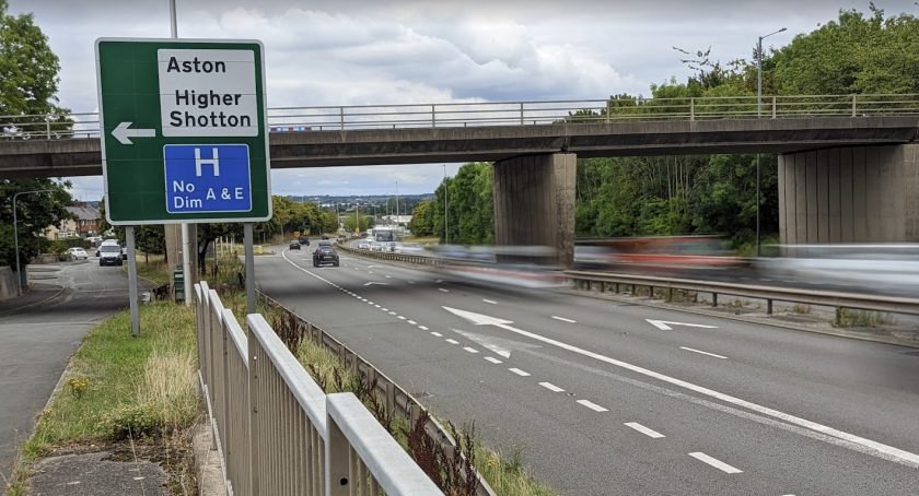
The scraping of the scheme has led to a major ‘pinch point’ on the A494 where three lanes merge into two on the westbound carriageway prior to the bridge, the merging lanes cause lengthy tailbacks at peak times.
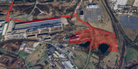
Further work has been undertaken to look at options to increase capacity within the A494/A55 corridor which led to the announcement in 2017 of the so-called ‘Red Route.’
A proposed 13km two-lane dual carriageway linking the A55 at Northop with the A494 and A550 north of Deeside Parkway Junction via the Flintshire Bridge.
It was chosen ahead of an alternative “Blue Route” route following a 12-week consultation in 2017.
The Blue Route plan would have seen improvements along the A494 Aston Hill and the Ewloe interchange with the A55 without the need for a new road being built.
In June last year the Welsh Government froze all new road-building projects as part of its plans to tackle the climate emergency.
An external panel was appointed in February of this year to carry out a year long review.
Despite the can being firmly kicked down the road when it comes to dealing with the congestion issue on the A494, the Welsh Government said it was committed to carrying out the work on the river crossing bridge.
Check live fuel prices near you before you set off.
Spotted something? Got a story? Email news (@) deeside.com
NEW: Add Deeside.com as a preferred source on Google to see more of our trusted coverage when you search.
Latest News