Storm Bert: Heavy rain and snowmelt combine to raise flood risks in Wales

Natural Resources Wales (NRW) and the Met Office are warning of significant flooding risks and severe weather as Storm Bert moves across the UK.
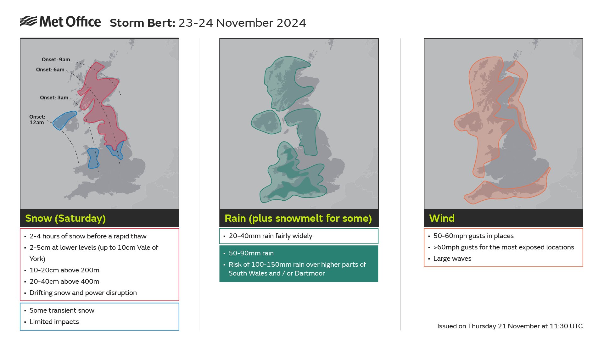
Wales is set to face heavy rainfall, rapidly melting snow, and strong winds beginning early Saturday (23 Nov).
The Met Office has issued a yellow warning for rain across most of Wales, effective from 6am Saturday to 6am Sunday.
A separate yellow wind warning applies to the North West and West Wales coastlines from 5am to 7pm on Saturday, with gusts potentially exceeding 50-60 mph in some areas.
The heavy rain, combined with snowmelt, is expected to cause surface water flooding and rapidly rising river levels.

Areas previously impacted by snowfall are particularly at risk, with significant disruption anticipated throughout the weekend.
Jason Kelly is a Met Office Chief Meteorologist and said: “Storm Bert starts to arrive overnight on Friday and into Saturday, initially over Northern Ireland.”
“As we go through the first part of Saturday morning, it will start to show its hand across Scotland, north Wales and northern England, with the potential for some heavy snowfall, especially over higher ground.”
Jason said: “Storm Bert is what we call a ‘multi-hazard event’, bringing snow, rain and wind to the UK for the majority of the weekend.”
“Multiple National Severe Weather Warnings are in place and will be added to and amended over the weekend.”
“It’s possible this may be at short notice, so it is important people keep up to date with the very latest forecast.”
Preparedness Across Wales
NRW teams are working closely with emergency responders and local authorities to monitor river levels and ensure flood defences are in working order.
Flood alerts and warnings will be issued if rivers reach critical levels, with updates available on the NRW website every 15 minutes.
Katie Davies, NRW’s Duty Tactical Manager, urged the public to remain alert:
“The predicted heavy rain and strong winds from Storm Bert, coupled with snowmelt, are likely to cause disruption across Wales this weekend.”
“We’re advising people to keep up to date with flood alerts and warnings and to take steps now to prepare their homes and businesses.”
Katie added: “Our teams are doing everything they can to reduce risk, but we urge people to avoid swollen rivers and not to drive or walk through flood water. It’s often deeper than it looks and could contain hidden hazards.”
Key Safety Advice
NRW and the Met Office recommend the following precautions:
- Check for Alerts: Stay updated on flood alerts and warnings via naturalresources.wales/flooding or by calling Floodline on 0345 988 1188.
- Prepare Your Property: Move valuables to higher ground, secure vehicles, and pack a flood kit with essentials like important documents and medication.
- Avoid Flood Water: Walking or driving through floodwater is dangerous and should be avoided.
- Plan Travel Carefully: If journeys are necessary, adjust driving behaviour and prepare for delays.
Mark Nash, National Network Manager at National Highways, echoed these warnings:
“Plan ahead for your journey and, if weather conditions become challenging, adjust your driving behaviour. Our website offers practical advice for travelling in storms and high winds.”
Looking Ahead
Storm Bert is expected to linger until Monday, with strong winds and showers continuing into the start of the week. Residents are encouraged to monitor forecasts and updates as conditions may evolve rapidly.
For the latest information, visit the NRW website, the Met Office, or follow @NatResWales and @metoffice on X (formerly Twitter).
Spotted something? Got a story? Email: [email protected]
Latest News
