Snow and ice warning for parts of North Wales
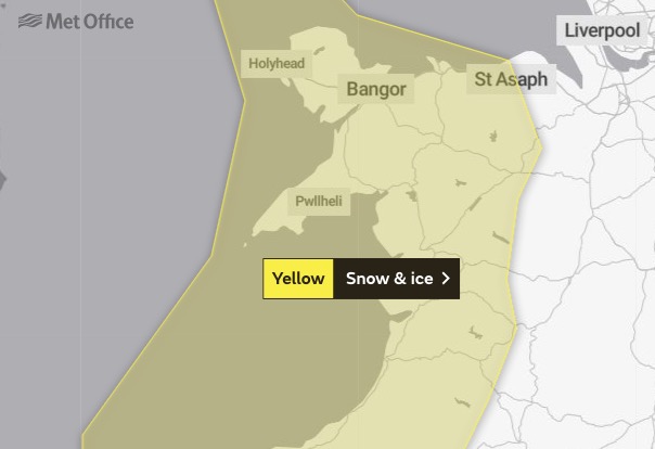
A yellow weather warning has been issued for parts of North Wales with snow and ice set to hit the region.
The Met Office has advised that wintry showers may lead to some travel disruption as the warning comes into place at 10pm tonight.
Effective until 10am tomorrow, it covers Anglesey, Gwynedd, Conwy and Denbighshire.
The Met Office says: “Wintry showers persisting through the night onwards into Tuesday morning accompanied by windy conditions will lead to patchy accumulations of 2 to 4 cm snow in some places, mainly inland and on hills.”
Flintshire isn’t covered by the Met Office warning but there have been some flurries of snow this morning
⚠️Snow – #A55 J32 Holywell to J34 Ewloe⚠️
Reports of snowfall on the #A55, please drive to the conditions and allow more time to travel. #TrafficWalesAlerts pic.twitter.com/bqtNf7uUwW
— Traffic Wales North & Mid #KeepWalesSafe (@TrafficWalesN) April 5, 2021
The Met Office has said temperatures are expected to remain below average for the coming week.
Chief Meteorologist, Dan Suri, said: “The Met Office has been signalling a dramatic change in weather type for several days, with very cold air moving from the Arctic through Sunday night, bringing snow showers and freezing overnight temperatures and all accompanied by strong northerly winds accentuating the cold.
Although snow showers will predominantly affect the north and north west, they could occur almost anywhere in the UK early this week, at least temporarily.
Some areas will remain drier and see few, if any, showers, for example: the southeastern quarter of England and the Central Belt of Scotland.
Check live fuel prices near you before you set off.
Spotted something? Got a story? Email news (@) deeside.com
NEW: Add Deeside.com as a preferred source on Google to see more of our trusted coverage when you search.
Latest News