Storm Éowyn triggers Amber wind warning in Flintshire for Friday
Residents in Flintshire are being urged to prepare for significant disruption on Friday as Storm Éowyn brings strong winds and hazardous conditions.
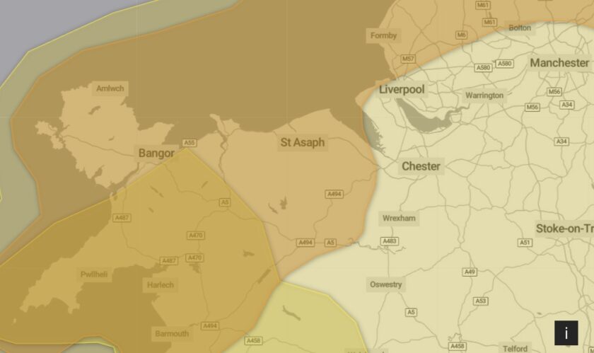
The Met Office has issued an amber weather warning, with gusts expected to reach 60–70 mph inland and up to 80–90 mph in exposed coastal areas.
The amber warning is in effect from 6 am to 9 pm on Friday, covering much of Flintshire. Meanwhile, Deeside will remain under a previously issued yellow warning.
The storm is forecast to sweep across the northwest of the UK, with winds easing later on Friday night.
The warning highlights the potential for widespread travel disruption, power cuts, and risks to safety, with the storm classified as having a “low likelihood but high impact.”
The strong winds are likely to cause delays and cancellations across road, rail, air, and ferry services.
Met Office Deputy Chief Meteorologist Mike Silverstone said: “Storm Éowyn will bring a period of very unsettled, potentially disruptive weather to the UK through Friday and into Saturday.
“The strongest gusts are likely to be felt across parts of Northern Ireland, northern England, northwestern Wales, and western Scotland, where exposed sites could get gusts in excess of 80 mph, which has the potential to cause impacts for those in these areas. There will also be some heavy rain, bringing unpleasant conditions to end the week.”
With Storm Éowyn’s winds and rain likely to impact road conditions, the RAC has urged drivers to take extra precautions.
RAC Breakdown spokesperson Alice Simpson said: “The wet and windy weather brought about by Storm Éowyn will make driving much more of a challenge towards the end of this week. Strong winds mean there’s a higher likelihood of fallen branches and trees on rural routes between motorways and A-roads, which can obstruct journeys and puncture tyres if not carefully avoided.”
Alice also warned about the dangers posed by sudden gusts, particularly along coastlines and exposed areas.
Drivers of high-sided vehicles are at greater risk of being blown off course, but cars may also be affected, especially when passing larger vehicles on motorways.
She advised reducing speeds and maintaining a firm grip on the wheel to avoid losing control.
Advice for Residents
The Met Office and local authorities are offering practical advice to help people stay safe during the storm:
- Secure loose items: Check your property for items such as garden furniture, trampolines, bins, and fences that could be blown away in the wind.
- Prepare for power cuts: Gather essential items such as torches, batteries, blankets, and mobile phone power banks in case of outages.
- Plan your travel: Check road conditions and public transport updates before setting off, and pack essentials if travelling by car.
- Stay off the coast: Avoid walking near cliffs and be mindful of large waves if visiting beaches or coastal areas.
In the event of an emergency, residents are advised to call 999 and ask for the Coastguard if affected by coastal dangers.
Why Amber?
The amber warning reflects increased confidence in the likelihood of high-impact conditions.
According to the Met Office, the strongest winds are expected to peak between 6 am and 9 pm on Friday, with Flintshire likely to be affected throughout the day.
Check live fuel prices near you before you set off.
Spotted something? Got a story? Email news (@) deeside.com
NEW: Add Deeside.com as a preferred source on Google to see more of our trusted coverage when you search.
Latest News