Met Office issues yellow alert for snow in Flintshire later this week

The UK is bracing itself for potential disruption as snow is set to hit parts of the country this week.
The Met Office has issued a yellow alert for heavy snow in Flintshire towards the end of the week.
The alert comes into play at 3am on Thursday and is in place until 6pm on Friday.
The Met Office yellow warning covers all on north Wales and large parts of central and northern England.
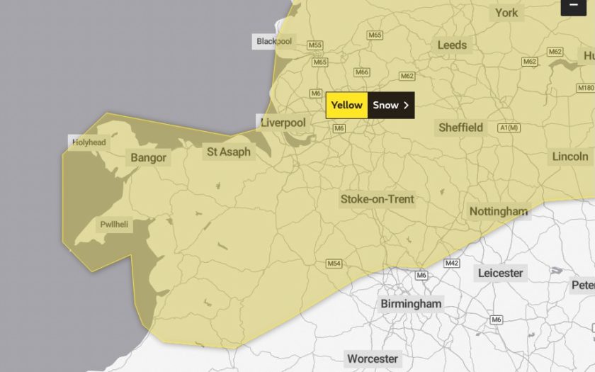
The Met Office has said: “Snow could develop quite widely across the warning area on Thursday and Friday as a potentially quite deep area of low pressure moves across the UK.”
“Parts of Northern Ireland, north Wales and northern England are currently expected to see the worst of the conditions on Thursday, with parts of Scotland and northern England then seeing the heaviest snow on Friday.”
“Event totals could bring 5 to 10 cm of snow to many locations, even at low elevations, with potentially 15 to 20 cm accumulating across the northern portion of the warning area.”
“Higher elevations of the North Pennines, Southern Uplands, higher parts of the Central Belt and the southern Highlands may see as much as 30 to 40 cm of snow in places.”
“In addition, there is potential for strong winds, which may lead to blizzard conditions and drifting of lying snow.”
Met Office Deputy Chief Meteorologist Steven Keates said: “The impactful weather will continue through the second half of the week as mild air meets cold air with further snow, ice, wind and then rain likely later in the week and into the weekend.
“From Wednesday, the focus of further snow is across parts of southern England and south Wales, with snow likely to lower levels for a time, and many may wake up to a couple of centimetres of snow on Wednesday morning.
“Through Thursday and Friday the snow risk spreads to central and northern areas of the UK, though it’s not possible to pick out precise locations regarding who will see the heaviest snowfall. With a developing situation, it’s important to stay up to date with the latest forecast and further warnings are very likely.”
By Friday, winds will also be increasing as low pressure moves in from the west. It remains uncertain where the boundary between the mild air to the south and cold air to the north will lie exactly, but southern areas are more likely to see cloud, wind and rain, while areas to the north of that boundary could see further disruptive snowfall, with strong winds possibly creating snowdrifts in places.
Impact:
This is what the Met Office website states.
-There is a small chance that long delays and cancellations on bus, rail and air travel could occur
-There is a slight chance that roads may become blocked by deep snow, with many stranded vehicles and passengers
-There is a small chance that communities could be cut off for several days
-There is a small chance that long interruptions to power supplies and other services, such as gas, water, telephone and mobile phone coverage, may occur
Check live fuel prices near you before you set off.
Spotted something? Got a story? Email news (@) deeside.com
NEW: Add Deeside.com as a preferred source on Google to see more of our trusted coverage when you search.
Latest News