Sleet and snow expected in Flintshire later today
Sleet and snow showers are expected to hit Flintshire today according to forecasters.
A Met Office yellow alert for snow is in place from 7am on Thursday and is in place until 2pm on Friday.
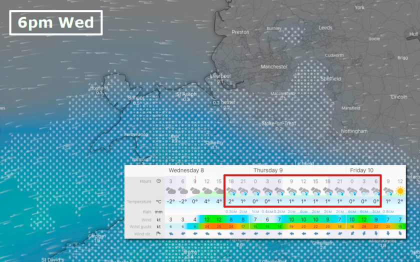
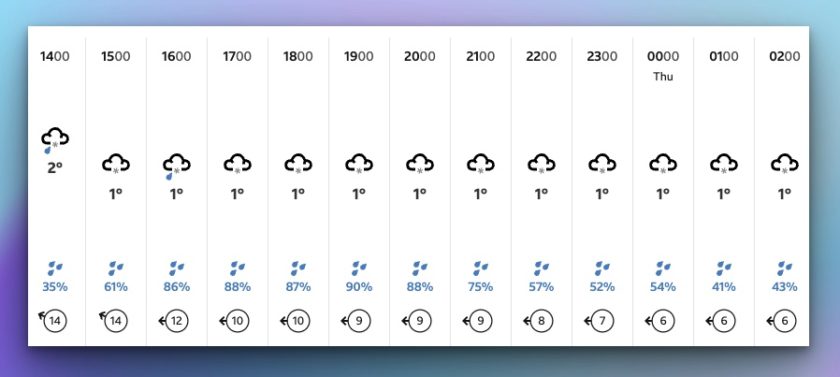
There are expectations of snow on higher ground and sleet on lower ground in some areas this afternoon, Wednesday, March 8th.
According to the BBC weather forecast, Hawarden is likely to experience sleet starting at 2pm, followed by light snow from 5pm that is expected to continue throughout the night.
[Image: BBC]
From 7am on Thursday and the Met Office yellow warning covering all on north Wales and large parts of central and northern England comes into play.
The Met Office has said: “An area of low pressure will move across the UK on Thursday and Friday with snow developing across Wales and central England early on Thursday morning.”
“This is expected to move slowly north during the day, becoming slow-moving across north Wales, northern England, Northern Ireland and southern Scotland during the afternoon and evening before slowly clearing southeast on Friday.”
“Snow will likely turn to sleet or rain at times at lower elevations, especially in the south of the warning area, as well as near eastern coasts.”
“At low levels including major cities such as Manchester, Liverpool and Newcastle accumulations are expected to be limited with a small chance of 2-5 cm falling.”
“However, significant snow accumulations are possible over hills of northern England (including populated areas of South and West Yorkshire), Northern Ireland and southern Scotland.”
“Here, 10-15 cm is expected quite widely above 100 metres, with a chance that 25-40 cm could fall in some places . Additionally, there is potential for strong winds, which may lead to blizzard conditions and drifting of lying snow. Ice is likely to develop widely on Friday night as this system clears away..”
Met Office Deputy Chief Meteorologist Helen Caughey said: “The impactful weather will continue through the latter part of the week as mild air pushing in from the southwest meets colder air in situ with further snow and ice for many areas.
“Through Thursday and Friday the snow risk spreads, to central and northern areas of the UK, with the potential of some significant accumulations even to low levels, which have the potential to cause impacts.”
“Parts of Northern Ireland, Wales and northern England are expected to see the worst of the conditions develop from early on Thursday, with parts of Scotland and northern England then seeing snow arrive through Thursday afternoon.”
“Snow across the northern half of the UK will persist through much of Friday, while further south, any snow will turn back to rain through Thursday afternoon and evening. Strong winds are also expected to develop through Thursday and Friday which may create drifting snow and blizzard conditions in places.”
Check live fuel prices near you before you set off.
Spotted something? Got a story? Email news (@) deeside.com
NEW: Add Deeside.com as a preferred source on Google to see more of our trusted coverage when you search.
Latest News