Met Office yellow warning for ice and snow extended through to Monday evening
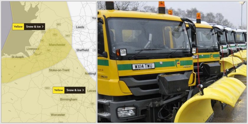
The Met Office has issued two yellow weather alerts for ice and snow for North Wales including Flintshire from Sunday evening.
Parts of the region could see a covering of snow on hills and as temperatures fall to between -2 and 0C.
Wintry showers and icy conditions are expected at lower levels.
The @metoffice has issued a yellow weather warning for snow and ice in #NorthWales for tonight into tomorrow morning. Icy conditions for us usually means more road traffic accidents and falls, so please take extra care and don’t be among them #WeatherAware pic.twitter.com/8luyoWU3iq
— Welsh Ambulance (@WelshAmbulance) December 27, 2020
The first alert, issued on Saturday has now changed and comes into play at 3pm today and is active until 10am on Monday.
It covers Flintshire as well as neighbouring counties in both Wales and England.
The Met Office says: “A band of rain, sleet and snow followed by wintry showers will move south across western and central parts of Scotland and Northern Ireland on Sunday evening and then into parts of northern England and north Wales early on Monday morning.”
“Localised accumulations of 1-3 cm are possible to lower levels but higher accumulations are likely over higher ground.”
“Above 250 metres, accumulations of 5-10 cm are possible.”
“Skies are expected to clear from the north overnight and widespread ice is likely to develop and persist through to Monday morning, especially across central and eastern areas.”
A second yellow alert issued today by the Met Office warns that “rain may turn to snow, which along with widespread ice, will lead to the potential for some disruption to travel and utilities.”
The alert is active from midnight tonight through to 6pm on Monday and again covers Flintshire as well as neighbouring counties in both Wales and England.
For this warning, the Met Office states: “An area of rain is likely to move south through Sunday night and Monday across parts of England and Wales.”
“There is the potential for this to turn to snow for a time.”
“There is a lot of uncertainty in where snow develops with some areas seeing little or no accumulations.”
“However, there is a very low likelihood of 1-3 cm, and locally 5-10 cm falling in a few places, particularly over higher ground of Wales above 200 metres.”
“As well as snow, widespread ice may also be an issue, especially where treatment has been washed off road surfaces.”
Check live fuel prices near you before you set off.
Spotted something? Got a story? Email news (@) deeside.com
NEW: Add Deeside.com as a preferred source on Google to see more of our trusted coverage when you search.
Latest News