Chester Zoo project maps human-elephant conflict zones

An ambitious research project led by Chester Zoo scientists is helping conservationists predict and prevent deadly human-elephant encounters in India.
More than 500 people and up to 100 elephants die each year as a result of human-wildlife conflict in the country.
To reduce those losses, researchers have developed a new map predicting where future conflicts are most likely to occur, based on thousands of past incidents.
The first phase of the work has been published in the journal Global Ecology and Conservation, in a paper titled “Spatiotemporal distribution of negative human-elephant interactions in Wayanad district, Kerala.”
The study was co-authored by Dr Alexandra Zimmermann of the Wildlife Conservation Research Unit, Oxford; Chester Zoo scientists Jacqui Morrison, Mayukh Chatterjee, Sue Walker and Scott Wilson; and K. Ramkumar and Sandeep Tiwari of the Wildlife Trust of India.
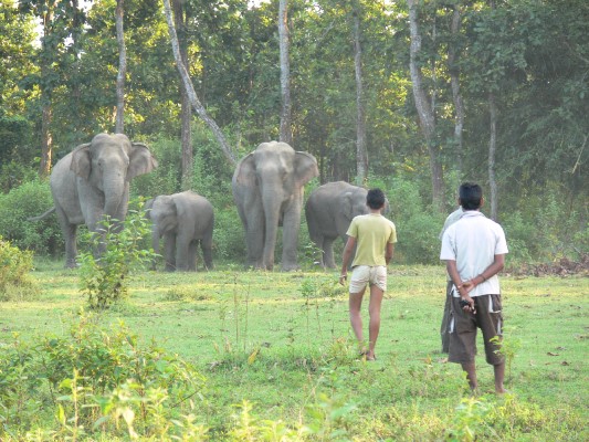
Jacqui Morrison said: “Elephants are intelligent and charismatic animals, but their habitat has shrunk to seven per cent of their historic range. To them, a field of crops is a highly nutritious source of food. But to the subsistence farmers and wider communities, a crop foraging event can be a real threat to their livelihoods and welfare.
“Wayanad district in the southern Indian state of Kerala is the site of key habitats for elephant herds, but approximately 70 per cent of that land is now used for agriculture, mainly rubber and coffee plantations.
“Conservationists are aware that interactions can negatively impact both elephant and human lives and put mitigation in place, however conservation resources are always limited. This work will help them prioritise high risk areas.
“The idea is that conservationists along with forestry departments and organisations such as the Wildlife Trust of India, can use this map on the ground.”
The new map combines data from 15 variables, including population density, proximity to protected areas and local climate. Unlike most conflict prediction tools, it uses environmental data from the actual time of historic incidents, offering a much finer level of detail.
Researchers used ten different algorithms to analyse data from almost 2,000 recorded human-elephant incidents, creating a more accurate way to forecast potential hotspots.
In the project’s second phase, more than 1,000 people living across the 2,000 km² study area have been surveyed about their attitudes to elephants. This social data has been integrated into the mapping model and will form the basis of a forthcoming paper.
Mayukh Chatterjee said: “Human-wildlife conflict has generally been measured in terms of the reported damage to humans, animals and property. It’s been assumed that reports of crop raiding events are proportional to conflict. But the issue is more complex than that, and by relying on reported damage as the sole metric, there’s a risk that the current picture is grossly erroneous.”
He added that hostility to certain species can exist even in areas with few direct encounters. “We believe intolerance is a primary driver of conflict,” he said. “There may be regions where elephants are encountered frequently and peacefully, or regular crop foraging events are tolerated by people. In contrast, there may be regions where encounters with elephants are rare, but they are met with much greater intolerance.”
By combining social attitudes with environmental and historical data, the team’s map aims to predict true conflict hotspots — areas where both elephants and people are most at risk.
While the study focuses on Kerala, its methods could be applied to other regions and species. Chester Zoo says it already supports several initiatives in India to reduce human-wildlife conflict, including training local volunteers to respond to big cat incidents and community fence-building projects to keep elephants away from crops.
Check live fuel prices near you before you set off.
Spotted something? Got a story? Email news (@) deeside.com
NEW: Add Deeside.com as a preferred source on Google to see more of our trusted coverage when you search.
Latest News