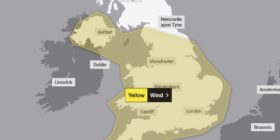
YELLOW WEATHER ALERT for snow in Flintshire issued by the Met Office

[vc_row padding_top=”14px” padding_bottom=”0px” bg_video=”” class=”” style=””][vc_column fade_animation_offset=”45px”][text_output]The met office has issued a ‘yellow alert’ for snow in Flintshire this evening.
Rain showers are expected to become more frequent from around 6pm this evening, increasingly they will turn to snow on high ground and inland, with a longer spell of sleet and snow moving southeastwards across Wales.

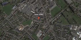
Met Office snow warning – map shows Deeside could be hit by snow showers – to the bunkers people…
Snow accumulations of 5-10 cm are likely across Wales above 200 metres, with 1-4 cm possible at low levels well inland from the coast. Ice is also likely to form on untreated surfaces.
A Met Office aviation briefing for the same period states there will be only ‘slight rain and snow mixed’ – (often called sleet!) for those of us in Deeside.

The snow warning is in place until 11am on Friday, it’s possible there will be travel disruption and difficult driving conditions in parts of the region with ice forming on untreated surfaces.
Flintshire woke up to a light dusting of snow this morning with reports of snow on higher ground including Buckley and Holywell.[/text_output][/vc_column][/vc_row][vc_row inner_container=”true” no_margin=”true” padding_top=”0px” padding_bottom=”0px” bg_video=”” class=”” style=””][vc_column fade_animation_offset=”45px” width=”1/6″][gap size=”1px” id=”” class=”” style=””][/vc_column][vc_column fade_animation_offset=”45px” width=”2/3″][text_output]
Winters here , well just a little bit ❄️❄️❄️ pic.twitter.com/TAH4fIE61v
— Alan Ball (@Cloudy2clear) January 14, 2016
[/text_output][gap size=”14px” id=”” class=”” style=””][text_output]
Nice snow scene to get up to in Rhosesmor @bbcwales @bbcweather @ITVWales @FlintshireChron #snow #flintshire pic.twitter.com/07tkLDsl8O
— Miss S (@Miss_KES) January 14, 2016
[/text_output][gap size=”14px” id=”” class=”” style=””][text_output]
@DerekTheWeather A light dusting of snow in Caerwys, Flintshire pic.twitter.com/k5kv20g4oO
— N J B (@nbefc73) January 14, 2016
[/text_output][/vc_column][vc_column fade_animation_offset=”45px” width=”1/6″][/vc_column][/vc_row][vc_row padding_top=”0px” padding_bottom=”0px”][vc_column fade_animation_offset=”45px” width=”1/1″][text_output]The met office Chief Forecaster’s assessment
Please be aware of the likelihood of some travel disruption and difficult driving conditions.
A cold, unstable northwesterly airstream covers the UK.
This will bring showers, which will become heavier, more frequent and increasingly wintry later on Thursday.
In addition, a trough will bring a more persistent spell of sleet and snow southeastwards overnight – most of the snow falling across Wales, but smaller amounts may feed down into some western parts of England.
Amounts of snow towards the south and east of the warning area are uncertain and many places will see very little, but ice will be a likely hazard in any case.
Met Office weather warnings guide[/text_output][/vc_column][/vc_row]
Spotted something? Got a story? Send a Facebook Message | A direct message on Twitter | Email: News@Deeside.comLatest News